Chart your course
Land Breeze vs Sea Breeze
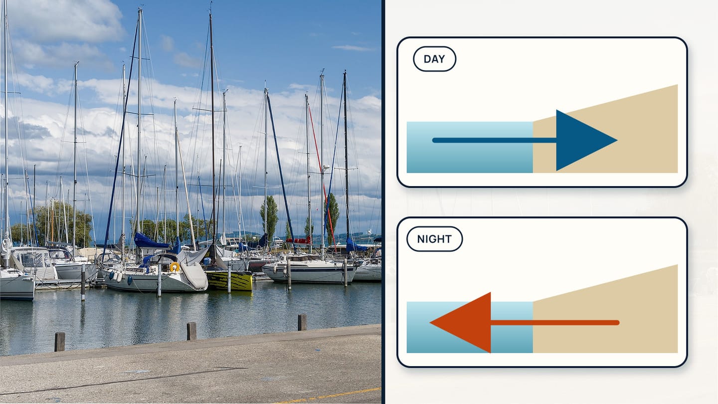
Quick answer
The short version
A sea breeze is a local daytime circulation that can carry surface wind from cooler water toward warmer land. A land breeze is the possible overnight reversal, with cooled land helping drive surface flow toward the water. Both depend on temperature contrast and can be altered or overwhelmed by the larger weather pattern, coastline shape, terrain, clouds, and season. Use them as a forecast question, then confirm the answer with official weather information and observations along your actual shore.
The labels describe where the surface flow comes from, not a guaranteed daily timetable. A sunny coast may develop a clear onshore breeze. The next day, stronger gradient wind from a weather system may prevent the local reversal. A narrow bay can turn the apparent direction, while hills can channel it. The useful skill is recognising a local circulation inside a larger forecast.
Build that skill beside how to read a marine forecast, lifts and headers explained, and how apparent wind works. Local forecast services may name and model coastal effects differently. Check the current official product and harbour observations rather than relying on a remembered clock time.
Both are local circulations driven by the same temperature contrast, running in opposite directions at opposite times of day.
| Dimension | Sea breeze | Land breeze |
|---|---|---|
| Timing | Daytime | Overnight |
| Surface flow direction | Onshore — from water toward land | Offshore — from land toward water |
| Driving contrast | Land warmer than water | Land cooler than water |
| Typical strength | Often more robust | Often lighter, less robust |
| Part of a circulation | Yes — return flow moves aloft in the opposite direction | Yes — return flow moves aloft in the opposite direction |
Learn the heating and cooling pattern
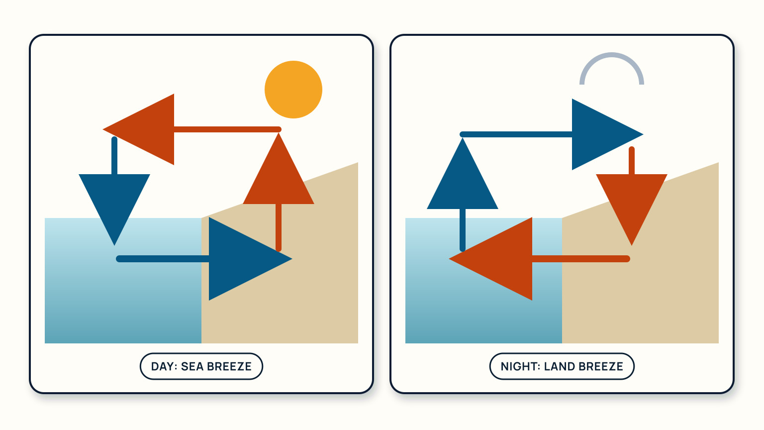
Land usually changes temperature faster than a large body of water. On a sunny day, warmer air over land rises and a local pressure difference can draw cooler surface air inland from the water. The return flow occurs higher up, completing a circulation. The sailor sees the lower part as an onshore sea breeze.
After sunset, land can cool faster than the water. The temperature contrast may reverse, allowing a lighter surface flow from land toward water: a land breeze. It is often less robust than the daytime sea breeze because the contrast and mixing differ, so do not assume the night version will simply match the afternoon one in reverse.
Cloud cover changes the heating. Wet ground, snow, warm currents, urban surfaces, and terrain also alter the contrast. The coastline's orientation determines what “onshore” and “offshore” mean at each point. Sketch the local shore and add arrows before translating the concept into a sailing course.
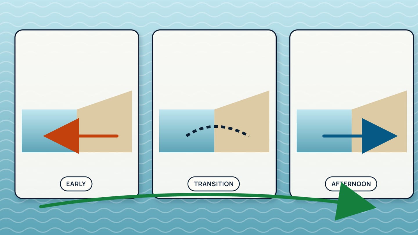
The pattern also has transitions. Morning may begin with light offshore flow, pass through a variable period, then settle onshore. Evening can fade or veer without establishing a clear land breeze. Those light, uncertain intervals matter because a sailboat may lose steerage near traffic or a lee shore.
How does the breeze arrive at the shoreline?
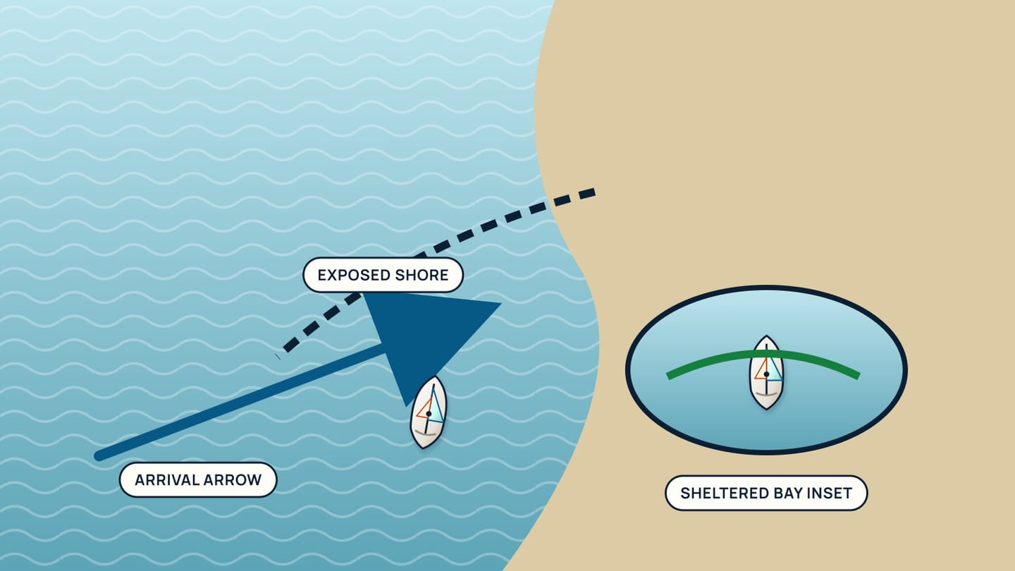
Look for a boundary advancing from the water. A darker or more textured band may spread toward the coast as the sea breeze fills. Flags at beaches and headlands may change before sheltered marina flags. Boats farther offshore can heel or alter trim while yours remains in light air.
Temperature and cloud can add context. Small cumulus clouds may build over heated land while the marine air remains clearer, though cloud appearance alone cannot confirm the wind. An onshore coolness at the dock may follow the boundary. Compare those clues with an official coastal observation so you do not misread a passing gust as a circulation change.
Terrain bends the flow. A valley can funnel onshore air inland. A headland can accelerate or redirect it. Buildings and cliffs make the first few hundred metres patchy. The wind at the masthead in a marina may therefore differ from the open-water breeze shown by anchored boats outside.
Make observations at fixed places and times. Note wind direction at the berth, harbour entrance, and an exposed point. Repeating that small survey on several suitable days teaches more than one dramatic afternoon. It also reveals which local indicator leads the change and which one sits in a permanent wind shadow.
How do you separate local breeze from gradient wind?
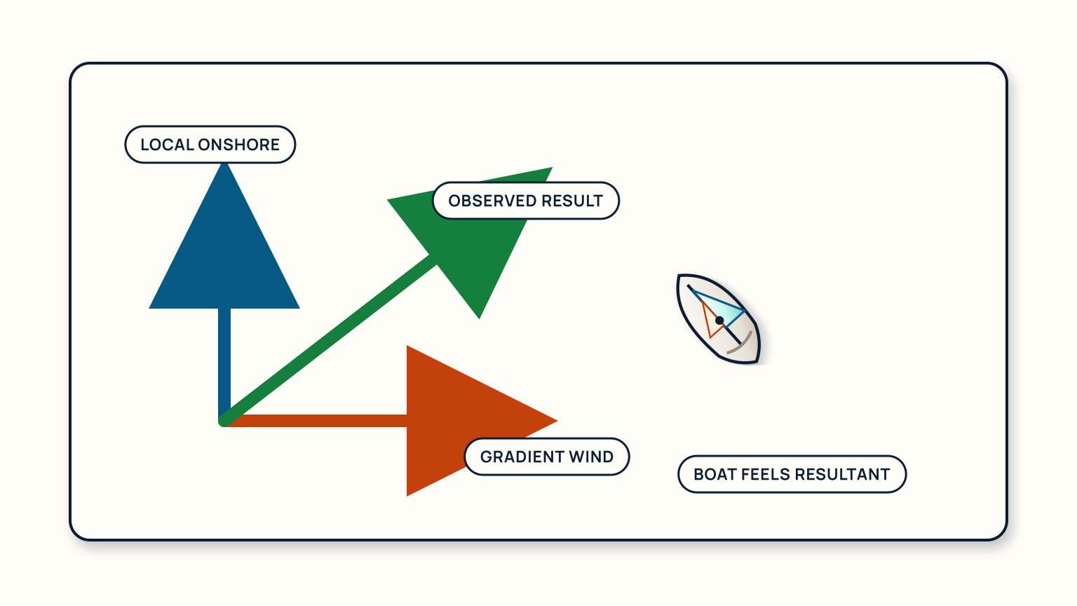
Gradient wind is the broader flow associated with the regional pressure pattern. A local sea or land breeze is superimposed on it. When the two point the same way, the coastal wind may strengthen. When they oppose, the result can be delayed, weakened, or variable. This interaction is why the local circulation cannot be forecast from sunshine alone.
Start with the synoptic or regional marine forecast. Identify the expected broad direction and strength. Then ask whether daytime heating supports an additional onshore component at your coast. A forecast discussion may explicitly mention coastal enhancement, convergence, or a sea-breeze front.
Use a vector picture rather than simple addition. If the broad wind runs alongshore and the sea breeze points onshore, the observed wind may turn diagonally between them. Around a curved coast, that combined direction can differ from bay to bay. A sailor following one compass heading may experience a lift in one reach and a header around the next point.
If observations do not match your local-breeze expectation, trust the evidence. Check whether the regional wind strengthened, clouds limited heating, or the boundary remains offshore. Do not wait in a hazardous place for the “usual afternoon breeze” to rescue a poor plan.
Plan for the transition, not one steady wind
Put the expected change on the trip timeline. A morning departure may use weak offshore land breeze, encounter a calm transition, and return in established onshore sea breeze. Every leg then has a different apparent-wind angle and exposure to shore.
Consider the return first. An onshore afternoon breeze can create short local waves and make a harbour approach different from the calm departure. An evening collapse may leave a sailboat slow near a tidal gate. Carry a propulsion and delay plan appropriate to the vessel, and preserve fuel or battery margin where relevant.
Choose decision points. Before rounding a headland, confirm whether the new wind has filled. Before leaving shelter, check the open-water texture. Before relying on a land breeze for an overnight leg, compare the actual temperature and wind trend with the official forecast. These checks keep a general pattern from becoming an unsupported promise.
Imagine a route out of a north-facing bay. The expected sea breeze arrives from the north and makes the outbound leg upwind. It also blows directly into the bay entrance on return. The same breeze that provides reliable sailing offshore may make the final approach rougher. Planning both directions avoids labelling the whole event simply “good wind.”
Keep testing the local explanation
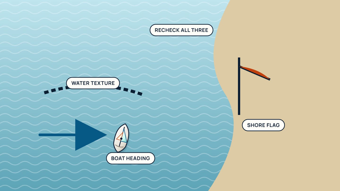
Once underway, compare forecast, observation, and boat response. Note the true directional clues ashore, the apparent wind aboard, and whether changes occur in sequence across the water. Recheck after headlands or major course changes because the same flow meets a new coastline geometry.
Avoid overfitting one day. A sea breeze that began at noon yesterday does not establish a noon rule. Record cloud, broad wind, temperature contrast, and the observed transition time. Patterns become useful only when their conditions are remembered with them.
Treat abrupt darkening skies or strong gust fronts as different weather until official information says otherwise. A thunderstorm outflow can reverse the wind rapidly and should not be explained away as an early land breeze. The appropriate preparation is based on the hazard, not on the most familiar label.
At the end of the sail, review the route by location. Where did the boundary appear? Which shoreline feature redirected it? Did the open-water observation lead the marina flag? That local map will help the next trip, while the official forecast remains the starting point each day.
Build a comparison rather than a folklore calendar. On three suitable days, record cloud amount, broad forecast wind, berth observation, exposed-shore observation, and the first sustained local change. The aim is not to predict another day from an average time. It is to discover which combination produced the familiar pattern and which days never developed it.
Use the record to challenge language aboard. “The sea breeze is late” assumes it must arrive. “The open-water wind remains offshore despite stronger land heating” states evidence and leaves room for the larger pattern. Precise observation keeps a useful coastal model from becoming an excuse to ignore the weather you have.
Compare the boat's apparent wind only after accounting for its course and speed. A change that appears during a tack belongs first to boat motion, while a shift repeated by anchored flags and vessels on several headings supports the local-wind explanation. This final cross-check keeps the coastal theory tied to independent evidence.
SailStarter's weather lessons help you connect heating, wind direction, and apparent wind before reading the coast in real time. Use them to prepare a local observation exercise with an experienced skipper, and keep every sea-breeze or land-breeze expectation subordinate to current official weather.
Try it from the lesson
Can you spot the next move?
A short ribbon on a supporting wire of the mast streams out sideways. What is it showing?
Why you can trust this guide
. We build each guide from public seamanship and safety sources, then teach the universal principle before any local difference.