Chart your course
Traffic Separation Schemes for Sailors
Quick answer
The short version
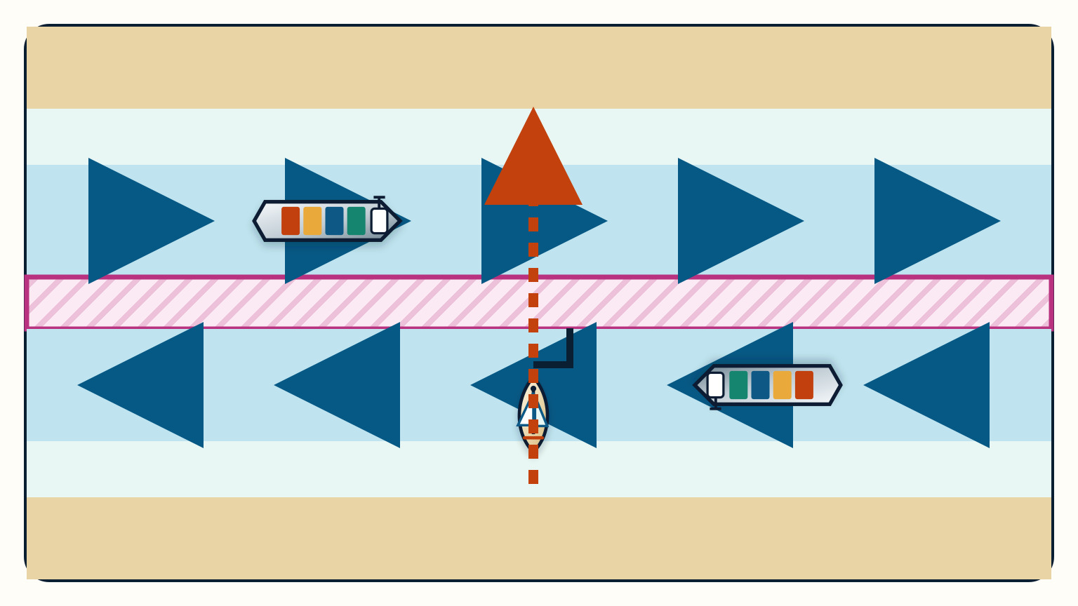
A traffic separation scheme, usually shortened to TSS, organizes ships into opposing traffic lanes with a separation line or zone between them. Rule 10 of the collision regulations tells every vessel how to use, cross, or avoid an IMO-adopted scheme. For a sailing vessel, the central practical duties are to avoid crossing when practicable, cross on a nearly right-angle heading when a crossing is necessary, and not impede a power-driven vessel following a lane.
Those duties do not create a motorway-style right of way. Lookout, safe speed, collision-risk assessment, and the other steering rules remain active. A ship in a lane must still comply with them, just as the crossing sailboat must. Plan from the current official chart and directions, verify any local reporting or operating provisions, and reassess the traffic before and throughout the passage.
How do you read a TSS on the chart?
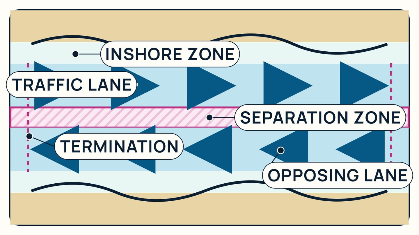
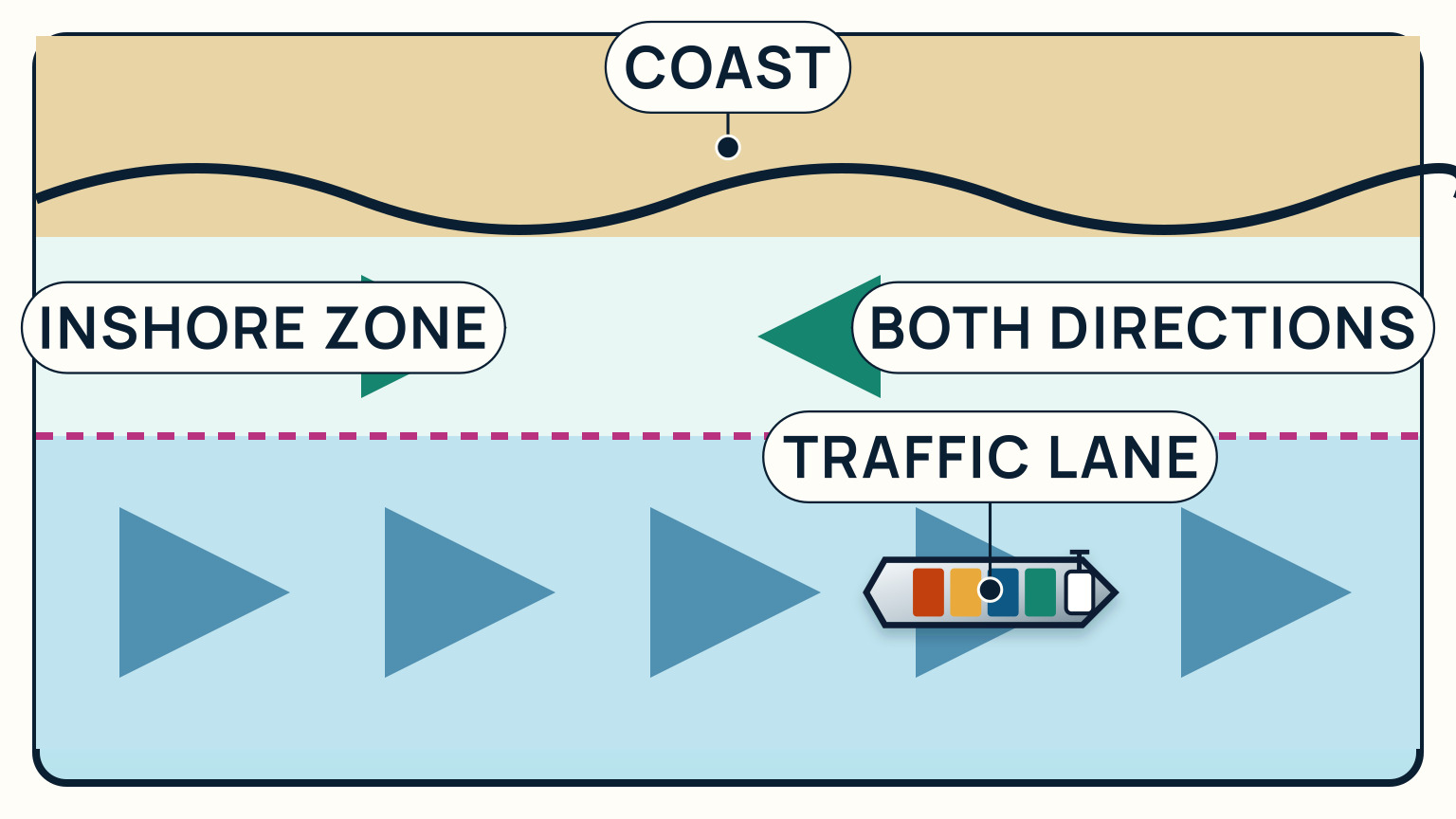
Begin by finding the whole routeing system, not only the pair of arrows nearest your intended track. A TSS normally has traffic lanes pointing in opposite directions and a separation line or zone between them. It may also have inshore traffic zones between the lanes and the coast, plus precautionary areas or terminations where routes merge. The exact arrangement belongs to that charted scheme.
Trace the boundaries and the general direction of flow in each lane. Then read every chart note and the referenced sailing directions or notices. Some schemes include provisions for particular vessel classes or local reporting. Chart display settings matter too: use a scale and layer combination that shows the routeing features clearly, and do not treat a small-screen overview as the passage plan.
Mark the place where you would enter, cross, leave, or remain outside. If your voyage does not use the scheme, Rule 10 says to avoid it by as wide a margin as practicable. If you will use a lane, proceed in its general direction, keep clear of the separation line or zone so far as practicable, and normally join or leave at a termination. A side entry or exit should make as small an angle to the lane's traffic flow as practicable.
The chart is also where you catch category errors. A separation zone is not an empty lane for yachts, and an inshore traffic zone is not automatically a one-way refuge. For comparison, narrow-channel rules apply a different chart-and-waterway test even though both situations include a duty not to impede certain vessels.
What does “shall not impede” mean here?
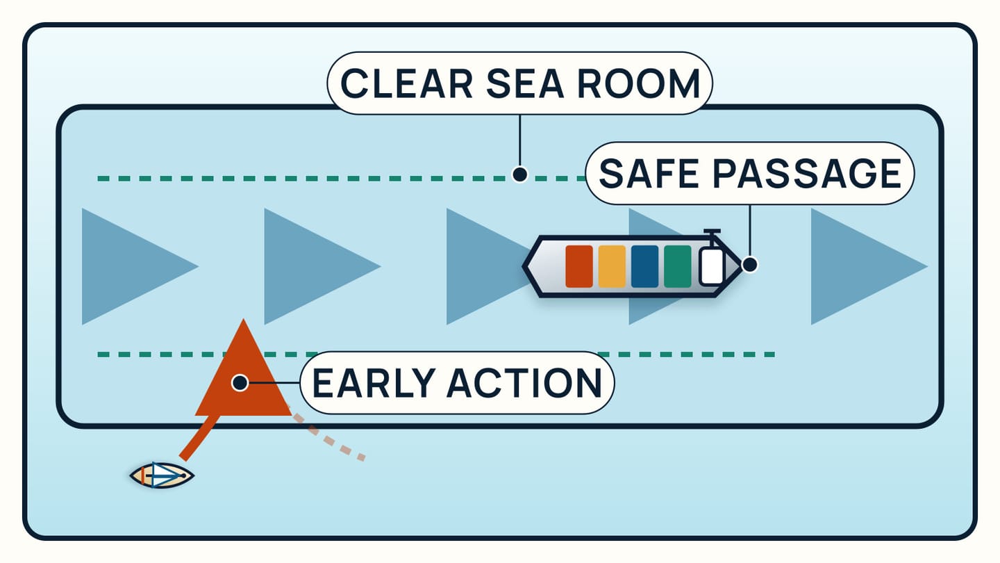
A sailing vessel, as well as a vessel shorter than 20 metres, must not impede the safe passage of a power-driven vessel following a traffic lane. This is an early planning duty. Rule 8 says the vessel required not to impede takes early action when the circumstances require it, allowing sufficient sea room for the other vessel's safe passage. Waiting until a ship must alter for you defeats that purpose.
The duty continues if the encounter develops into risk of collision. It does not erase the other collision rules or excuse either vessel from them. The lane-following ship remains responsible for lookout, safe speed, risk assessment, and whatever action the applicable steering rule requires. “The ship has priority” is therefore a poor mental model. Your job is to stay out of the way early enough that a close-quarters rules problem does not develop.
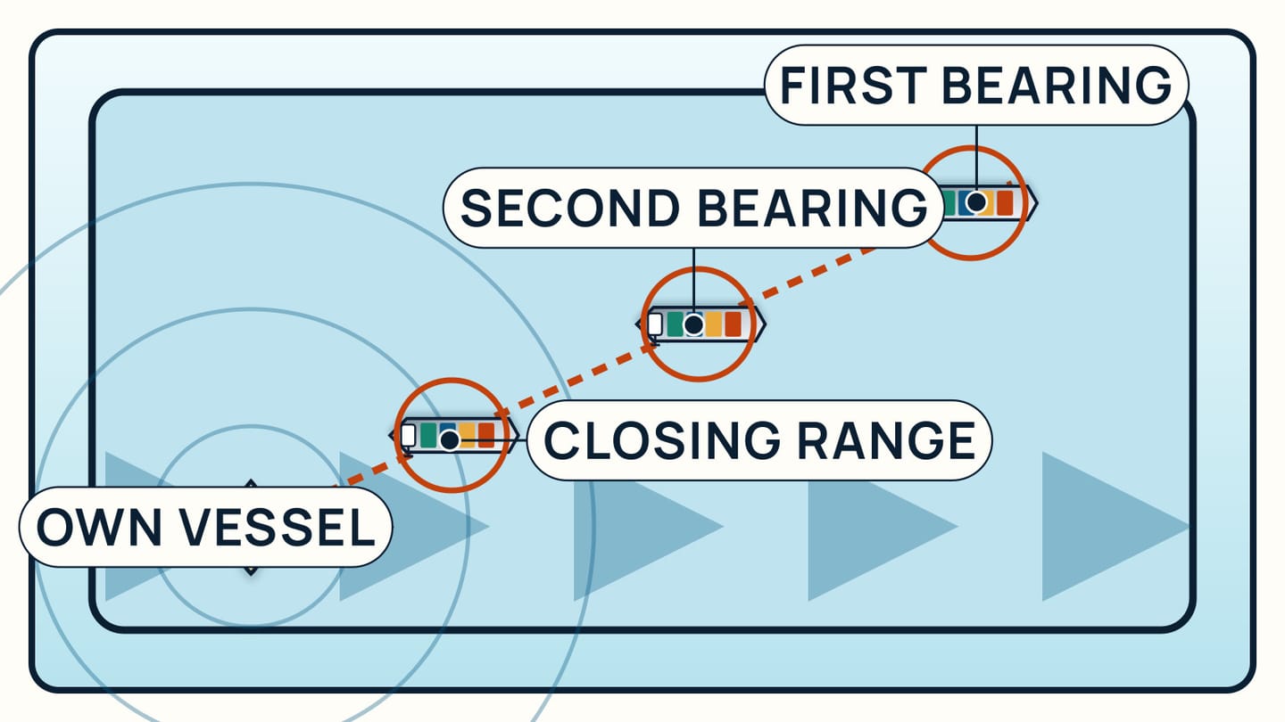
Before entering, identify ships already established in both lanes and those approaching a termination. Watch bearing and range over time rather than judging from one glance. If successive observations hold an approaching vessel on nearly the same compass bearing while its range closes, Rule 7 treats that as collision risk. Risk can still exist with a changing bearing when a very large vessel, tow, or close range is involved.
Choose a gap that leaves the lane-following vessel ample room without depending on a last-minute turn. The guide to whether sailboats have right of way explains why sail-over-power is only a starting rule, while Rule 10 adds this specific obligation in a traffic lane.
Cross on the heading Rule 10 specifies
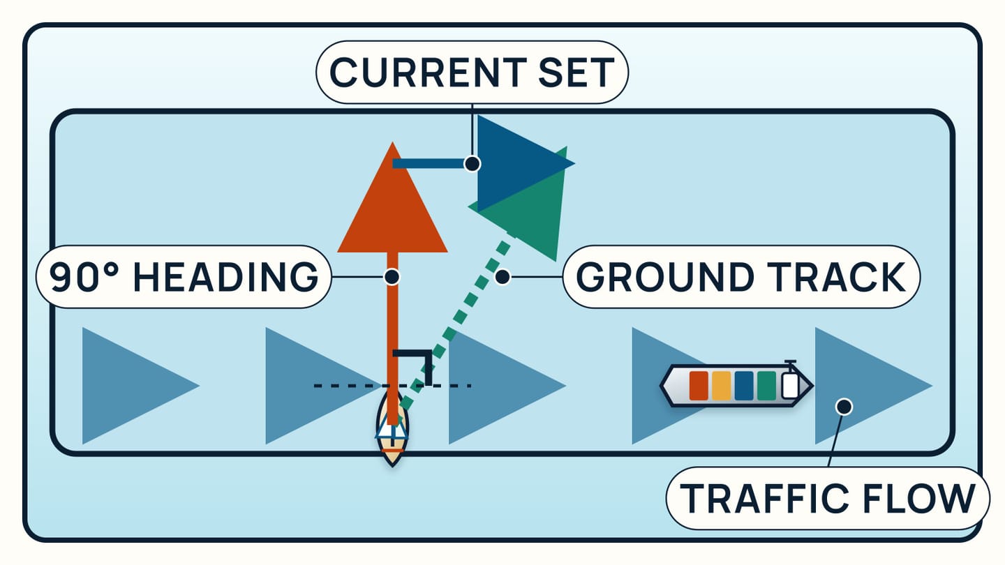
Rule 10 first says to avoid crossing traffic lanes so far as practicable. If you are obliged to cross, set a heading as nearly as practicable at right angles to the general direction of traffic flow. “Heading” is deliberate: it describes where the bow points, not necessarily the track drawn over the seabed by GPS.
A cross-current can carry the boat sideways. In that case the bow can remain perpendicular to traffic flow while the course over ground becomes diagonal. Do not crab into the current merely to make the plotter trace look square to the lane. Official guidance explains that the right-angle heading minimizes the time spent inside the lane regardless of tidal stream and gives lane traffic a clearer view of your intention.
This is different from joining or leaving a lane from its side. There, the rule calls for a small angle to the traffic flow, not a right angle. Draw the two manoeuvres separately during planning so a crossing does not gradually turn into travelling along the wrong edge of a lane or separation zone.
Wind and sea may make an exact compass number impracticable for a yacht, which is why the wording is “as nearly as practicable.” That qualification is not permission to wander. Establish the intended heading before the boundary, steer it consistently, and keep checking actual traffic. If the crossing cannot be made without impeding a lane-following power vessel, wait outside or choose another safe plan.
When may a sailboat use the inshore traffic zone?
Rule 10 allows sailing vessels and vessels under 20 metres to use an inshore traffic zone. The zone lies between the traffic scheme and the coast where the chart shows one. It is an available route, not a guarantee of quiet water or a lane reserved for small craft.
Expect vessels in the inshore zone to be heading either way. Boats may be travelling to or from ports, pilot stations, offshore structures, or other places within the zone. Traffic density, shoreline hazards, local routes, fishing activity, visibility, and your destination all belong in the decision. Read the particular chart and directions instead of assuming the inshore side is always preferable.
The permission for a sailboat to use the zone does not cancel Rule 10 elsewhere. Do not cut across the separation line to reach it except as the crossing provisions allow, and do not anchor in the TSS or near its terminations so far as practicable. Near a termination, use particular caution because lane traffic may be joining, leaving, or converging.
If the inshore route forces a difficult coastal passage while a lawful lane or route outside the scheme is safer, compare those real options. The rule describes who may use the zone; it does not select your passage for you. Current charted depths, hazards, routeing notes, weather, and the boat's capabilities still decide whether the route is safe.
Keep the collision picture alive
Rule 10 applies alongside the rest of the collision regulations. Post an effective lookout by sight and hearing and use all other appropriate available means. Proceed at a safe speed. Repeatedly assess bearing, range, lane direction, and developing traffic instead of assuming every target will keep following its present vector.
Make responsibilities explicit before the crossing. One person steers the planned heading, while another can maintain the wider scan and report changes without taking over the helm conversation. Check astern as well as along both lane directions. A fast vessel emerging from behind another ship or a target near a termination can alter the picture after the first assessment.
If avoiding action becomes necessary, Rule 8 calls for action that is positive, made in ample time, and readily apparent when circumstances permit. A string of small, ambiguous turns is hard for another bridge team to interpret. Check the result until the other vessel is finally past and clear. The guide to taking a compass bearing gives a fuller explanation of the bearing test, but no single observation or electronic target replaces the full lookout.
After the passage, note any mismatch between the plan and what happened: a routeing layer that was hidden, an unread chart note, a helm heading that was hard to hold, or a watch handover that lost a target. Fix that specific weakness before the next TSS. Rehearse the chart briefing ashore with the same display and controls used aboard, including how the crew will identify lane flow, report bearing changes, and distinguish heading from ground track.
SailStarter's visual lessons cover the wider sail-versus-power exceptions and collision-avoidance roles. Use them with current official charts, local directions, and practical instruction for the waters you sail. A lesson can make the geometry familiar; the passage still depends on an alert crew reading the live traffic and acting early enough to leave everyone useful sea room.
Try it from the lesson
Can you spot the next move?
A sailing vessel under sail alone and a power-driven vessel are in sight with collision risk. Neither is overtaking, and no channel, traffic scheme or qualifying restriction changes the encounter. Who keeps out of the way?
Why you can trust this guide
. We build each guide from public seamanship and safety sources, then teach the universal principle before any local difference.